A strange object discovered in New Mexico has led to an explosion of conspiracy theories online.
A peculiar, disc-shaped object resembling a ‘UFO’ has been spotted on Google Maps, stirring up eerie speculation across the internet.
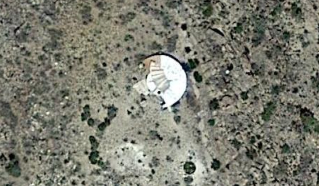
The structure, which bears an uncanny resemblance to an alien spacecraft, was found in the mountainous terrain of New Mexico, and its discovery has sparked a storm of theories online.
Sitting at the coordinates 34°24’21.6″N 107°05’44.5″W, about 34 miles from Sevilleta National Wildlife Refuge in La Joay, this white disc was noticed by users browsing Google Maps.

The disc on Google Maps has sparked several conspiracy theories
Google Maps/Twitter/@Ovniologia01
What makes this discovery even more mysterious is its remote location in the vast and desolate Sierra Ladrones. There are no visible roads, pathways, or buildings anywhere nearby, adding to the intrigue.
In the screenshots that have surfaced, the top of the circular structure appears to have a metallic-like surface with some kind of attached ‘hardware’. Meanwhile, part of the object is obscured by dense vegetation and surrounding brush.
The discovery was initially shared by a Twitter account known for its focus on UFOs and extraterrestrial theories.
The tweet stated: “Something in the shape of a disc embedded in a mountain in New Mexico, USA, at an altitude of 2,255 meters.”
Following this revelation, various theories have emerged. Some believe it could be a ‘calibration target’ used for satellite imaging, while others think it might be the remains of an old observatory or even a defunct water reservoir.
Reddit users quickly joined the conversation, with some speculating that it might actually be a ‘crashed UFO that got lodged into the mountain’.

Some suspected the disc was a crashed UFO
Google Maps/YouTube/MrMBB333
“I’m from New Mexico and very familiar with the area,” one person commented. “There’s nothing out there, pure desert, no way it could be a home and if it’s on a mesa I doubt one could drill for water. No reason [for there to be] a building there.”
Another user chimed in with a different perspective, stating: “I wondered about it being a modern home built into the earth, but there’s no suitable access road. And I checked the tax maps. This is on a government tract, and not privately owned.”
Interestingly, the oldest available Google Maps satellite image from 1996 shows an empty, undisturbed landscape—there was no sign of a disc or even a dirt road leading to the site at that time.

A close up of the suspicious object
Google Maps/Twitter/@Ovniologia01
A YouTuber named Michael, also known as ‘The Earth Watchman’ among his followers, took a closer look at the location and shared his thoughts: “This is a very remote location, nothing going on up here.”
“This looks very much like a disc that is stuck in the top of this mountain. I measured the disc from side to side, it’s around 30 feet across.”
Michael went on to suggest that the disc might have become partially buried in the earth after crash-landing in the rugged mountains.
Meanwhile, investigators from Metabunk—a website known for debunking conspiracy theories—searched for a more grounded explanation by reviewing historical records from the US Geological Survey.
Based on their findings, they concluded that the structure was originally ‘a rainwater catchment that was later removed and replaced with a different structure’. A photograph from 1975 showed that, at that time, there was only a small dot with a visible path leading toward it.
One of the Metabunk researchers added: “From a quick search there appears to have been a structure built on that exact spot from at least the 1975 so it seems unlikely anything coincidentally ‘crashed’ there.”